The structure of the Earth

- Lithosphere - the solid, outer layer of the earth that consists of the crust and the rigid upper part of the mantle
- Continental Crust - The portion of the earth's crust that primarily contains granite, is less dense than oceanic crust, and is 20-50 km thick
- Oceanic Crust - The portion of earth's crust that primarily contains basalt, is relatively dense, and is 5-20km thick
- Inner core - a dense sphere of solid iron and nickel at the centre of the earth
- Outer Core - the liquid layer of the Earth's core that lies beneath the Mantle and surrounds the inner Core
- Mohorovicic discontinuity - the zone between the crust and mantle that marks a boundary between the 2, discovered because it changes the speed of seismic waves
- Asthenosphere - The solid, plastic layer of the mantle beneath the lithosphere; made of mantle rock that flows very slowly, which allows tectonic plates to move on top of it
Continental fit
Some continents (such as the
western seaboard of Africa and the eastern seaboard of South America) seem to
fit together if placed side by side.
This is particularly true if the continental shelves are taken into account
as the true edges of the land masses.
Wegener suggested that all the
present continents were originally joined together to form a single
supercontinent called Pangaea before drifting apart into Laurasia in the north
and Gondwanaland in the south. Laurasia
and Gondwanaland then broke up to form the continental arrangement we know
today.
The similarity in outline of the coastlines of
eastern South America and West Africa had been noted for some time. The best
fit is obtained if the coastlines are matched at a depth of 1,000 metres below
current sea level.
Any areas where there are gaps or overlaps may be
explained by:
- Coastal erosion since continental separation
- Coastal deposition since continental separation
- Rises in sea level (eustatic change) since continental separation
- Changes in land level (isostatic change) since continental separation

There was only one problem with this
theory, which Wegener termed ‘continental drift’: he had no mechanism for
movement--that is, Wegener lacked an explanation for the ‘drift.’ He
hypothesized that the continents floated on the ocean, which is a laughable
suggestion even today. Wegener noted, however, that one
thing was certain: the forces which displace
continents are the same as those which produce great fold-mountain ranges.
Continental drift, faults and compressions, earthquakes, volcanicity, [ocean]
transgression cycles and [apparent] polar wandering are undoubtedly connected
on a grand scale.
Geological Evidence
 Rocks of the same age and type
and displaying the same formations are found in south-east Brazil and South
Africa. The trends of the mountains in
the eastern USA and north-west Europe are similar when they are placed in their
old positions. Similar glacial deposits
are found in Antarctica, South America and India, now many thousands of
kilometres apart. Striations (scratches
on rocks from movement of ice) and glacial deposits in Brazil match those in West
Africa.
Rocks of the same age and type
and displaying the same formations are found in south-east Brazil and South
Africa. The trends of the mountains in
the eastern USA and north-west Europe are similar when they are placed in their
old positions. Similar glacial deposits
are found in Antarctica, South America and India, now many thousands of
kilometres apart. Striations (scratches
on rocks from movement of ice) and glacial deposits in Brazil match those in West
Africa.
When the geology of eastern South America and West
Africa was mapped it revealed that ancient rock outcrops (cratons) over 2,000
million years old were continuous from one continent to the other.
Fragments of an old fold mountain belt between 450
and 400 million years ago are found on widely separated continents
today. Pieces of the Caledonian fold mountain belt are found in Greenland,
Canada, Ireland, England, Scotland and Scandinavia. When these land masses are
re-assembled the mountain belt forms a continuous linear feature.
Climatological Evidence

Coal deposits of similar ages (formed in warm tropical
conditions) are found in locations as far apart North America, Svalbard and
UK. These locations are no longer in
tropical climatic zones and must have drifted to more northerly climate zones
since the Carboninferous period.
Furthermore, today, glacial deposits formed during
the Permo-Carboniferous glaciation (about 300 million years ago) are found in
Antarctica, Africa, South America, India and Australia. If the continents
haven’t moved, then this would suggest an ice sheet extended from the South
Pole to the equator at this time - which is unlikely as the UK at this time was
also close to the equator. If the
continents of the southern hemisphere are re-assembled near the South Pole,
then the Permo-Carboniferous ice sheet assumes a much more reasonable size.

More evidence comes from glacial striations –
scratches on the bedrock made by blocks of rock embedded in the ice as the
glacier moves. These show the direction of the glacier, and suggest the ice
flowed from a single central point.
Biological Evidence:
There are many examples of fossils found on
separate continents and nowhere else, suggesting the continents were once
joined. If Continental Drift had not
occurred, the alternative explanations would be:
- The species evolved independently on separate continents – contradicting Darwin’s theory of evolution.
- They swam to the other continent/s in breeding pairs to establish a second population.
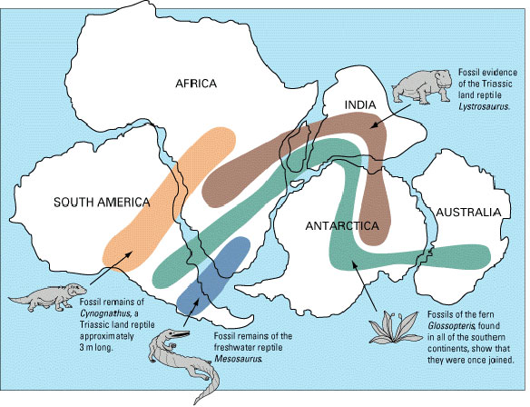
Remains of Mesosaurus, a freshwater crocodile-like
reptile that lived during the early Permian (between 286 and 258 million years
ago), are found solely in Southern Africa and Eastern South America. It would
have been physiologically impossible for Mesosaurus to swim between the
continents. This suggests that South America and Africa were joined during the
Early Permian.
Cynognathus is an extinct mammal-like reptile. The
name literally means ‘dog jaw’. Cynognathus was as large as a modern wolf and
lived during the early to mid-Triassic period (250 to 240 million years ago).
It is found as fossils only in South Africa and South America.
No comments:
Post a Comment